5 Golden Rules for 2026 Road Trips
-
Check the Air: Always check the AQI layer on Google Maps and carry N95 masks for wildfire smoke.
-
Never Trust the Shortcut: If a highway is closed for emergencies, do not take unpaved GPS detours.
-
The Half-Tank Rule: Never let your fuel or EV charge drop below 50% in remote or high-risk areas.
-
Stay With the Car: Whether stuck in a blizzard or a desert breakdown, your vehicle is your best survival shelter.
-
Use the "Trinity": Navigate using a combination of Google Maps (Big Picture), Waze (Live Hazards), and Watch Duty (Wildfire Tracking).
Hey there, road trip lovers! 👋 Planning a legendary American cross-country journey in 2026? While the views are iconic, mother nature is bringing some extra "spice" to the roads this year.
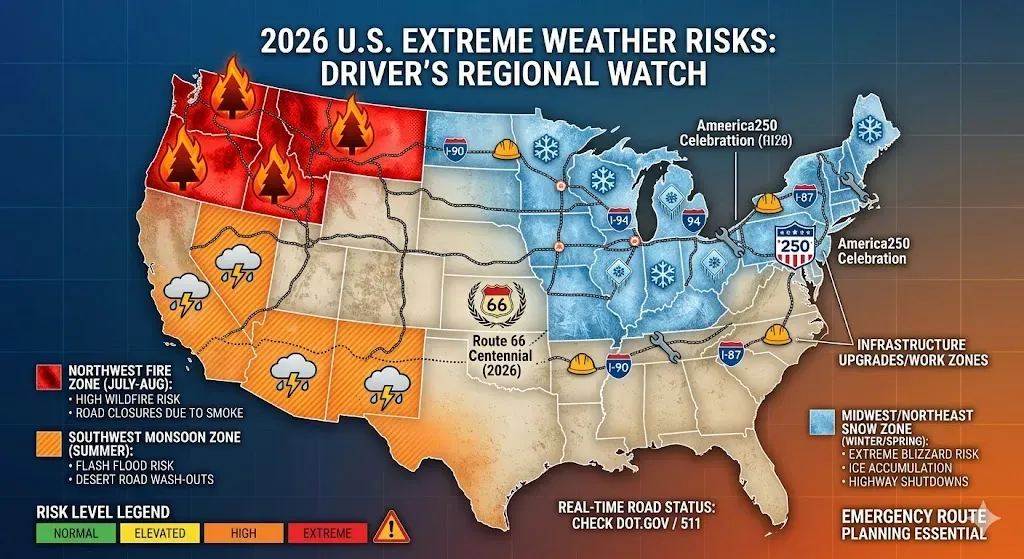
With 2026 predicted to have a highly volatile climate—early wildfires in the Pacific Northwest and unexpected late-season blizzards in the Sierras—you need to be more than just a driver; you need to be a strategic explorer. 🗺️
Don't worry! We’ve got you covered with this "no-fluff" guide to navigating real-time road closures and emergency planning. Let's hit the road (safely)! ✨
📅 Part I: 2026 USA Driving Reality Check: What’s Different This Year?
If you haven't hit the American pavement since 2024, the rules of the road have changed. 2026 is the year of The Great Anniversary and The Climate Wildcard.
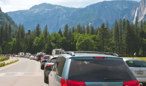
1. The "Open Gate" Chaos (National Parks)
The biggest shock for 2026 travelers is the rollback of reservation systems. In a controversial move to maximize access for the U.S. 250th Anniversary, heavyweights like Yosemite and Arches have scrapped their summer entry permits.
-
The Reality: "Open access" does not mean "easy access." Expect "Full Lot" signs by 6:00 AM and multi-hour queues at park gates.
-
The Survival Pivot: If you aren’t through the gates before sunrise, you are likely spending your morning in a gridlock.
2. The El Niño Wildcard
We are currently navigating a rapid transition to a strong El Niño. For drivers, this means the traditional weather maps are broken:
-
The Northern Burn: Washington, Oregon, and Idaho are facing "above-normal" fire potential through August due to a historic snow drought.
-
The Southern Soak: While the South usually welcomes rain during El Niño, the "flash-to-flood" cycle in the Southwest is more violent this year.
-
Atmospheric Rivers: The West Coast is seeing more frequent "River" events—intense plumes of moisture that can wash out sections of Highway 1 or I-5 in a single weekend.
3. The "Orange Barrel" Peak
The 2022 Bipartisan Infrastructure Law is hitting its physical peak in 2026. This is the year of Generational Construction.
-
The Pain Points: Massive overhauls on I-35 through Texas and bridge projects in the Pacific Northwest are creating "permanent" detours.
-
The Tech Gap: Standard GPS is lagging. In 2026, AI-integrated traffic platforms (like the new DOT "Smart Corridor" pilots) are the only way to navigate around work zones that can change daily.
4. The 250th Anniversary Surge
It’s not just a road trip; it’s a pilgrimage. From the Freedom 250 events in the Northeast to the FIFA World Cup matches across 11 U.S. cities in June, the sheer volume of "event traffic" is unprecedented.
-
The Reality: Hotel and campsite availability along historic routes (like Route 66 or the East Coast Corridor) is effectively zero if not booked 9–12 months in advance.
📜 2026 Quick-Glance Risk Table
| Challenge | 2026 Trend | Survival Strategy |
| Park Entry | No Permits (Yosemite/Arches) | Arrive at 4:30 AM or visit at Night. |
| Air Quality | PM2.5 Spikes (NW/CA) | Pack N95s and a portable air purifier for the car. |
| Navigation | Ghost Detours | Use Waze + Watch Duty + local DOT Twitter feeds. |
| Fuel/Charging | EV Network Expansion | Use the new NEVI chargers; 2026 has 40% more rural plugs than 2024. |
📱 Part II: Your Digital Co-Pilots (Essential Tools)
In 2026, the American open road is smarter, but also more volatile. With El Niño driving erratic weather and a historic surge in infrastructure projects, your smartphone is your most critical piece of survival gear.
Download these tools now, and move them to your home screen for instant access.
1. The Early Warning System: Watch Duty
While government alerts can lag, Watch Duty is the 2026 gold standard for wildfire safety. It is powered by a network of human dispatchers who monitor radio scanners 24/7 to provide information faster than any official agency.
-
The 2026 Edge: It provides real-time "Air Attack" flight paths and fire perimeters.
-
Survival Tip: Enable notifications for every county on your route. If you see smoke, check Watch Duty before the local news—it could save you hours on an evacuation route.
2. The Weather Tactician: Clime (NOAA Radar) & Windy.com
Standard weather apps give you icons; these give you data.
-
Clime: Best for "Now-casting." Its high-resolution NOAA radar is essential for spotting Flash Floods in the Southwest or Snow Squalls in the Rockies before you drive into them.
-
Windy.com: The ultimate visualization tool. In 2026, use the "Aerosol" layer to track PM2.5 smoke plumes. If your destination is downwind of a fire, Windy will show you exactly when the smoke will arrive.
3. The Anniversary Guide: Explore250
Launched for the U.S. Semiquincentennial (250th Anniversary), Explore250 is a partnership between the DOT and General Motors.
-
The 2026 Edge: Beyond historical trivia, it features a "Digital Passport" to 250 iconic locations. Most importantly, it integrates with local traffic data to show you which anniversary events are causing the biggest gridlock.
4. The "Orange Barrel" Navigators: Waze & State 511 Systems
2026 is the peak of the Bipartisan Infrastructure Law’s construction cycle.
-
Waze: Essential for "Ghost Closures." While Google Maps is great for businesses, Waze’s community-led reporting catches 3:00 AM emergency pipe repairs or sudden lane shifts on I-35 that other maps miss.
-
State 511 Systems: Every state has a 511 app (e.g., 511ia.org for Iowa, 511wi.gov for Wisconsin). In 2026, these are the only official sources for "Long-Term Construction Previews" and camera feeds of mountain passes.
5. The Command Center: Google Maps
While specialized apps provide niche data, Google Maps is your essential integration hub. In 2026, its utility has shifted from simple turn-by-turn navigation to comprehensive environmental awareness.
-
The 2026 Edge: Air Quality Index (AQI) Layer With "Smoke Season" becoming a reality in the West, the AQI layer is non-negotiable. It allows you to visualize smoke plumes in real-time, helping you decide whether to recirculate your car's air or bypass a high-pollution valley entirely.
-
Wildfire Search & Boundaries By simply searching for "Wildfires near me," Google Maps aggregates satellite data to show active fire perimeters and red-shaded danger zones directly on your route.
-
Offline Maps (The Safety Net) 2026 still has massive "Dead Zones" in the High Desert and the Rockies. Google Maps allows you to download massive chunks of map data (including points of interest and gas stations) that function without a single bar of cellular service.
-
Immersive View for Crowd Control For the USA 250 celebrations, use the "Immersive View" and "Busy-ness" predictors. It uses AI to forecast peak crowds at major monuments, allowing you to pivot your arrival time to avoid the 2026 tourist surge.
💡 The "Trinity" Navigation Strategy:
To stay safe in 2026, use these three in tandem:
-
Google Maps: For the "Big Picture"—AQI layers, offline maps, and finding food/fuel.
-
Waze: For the "Micro-View"—dodging sudden construction (Orange Barrels) and speed traps.
-
Watch Duty: For the "Crisis-View"—checking specific evacuation orders if Google Maps shows a fire on your path.
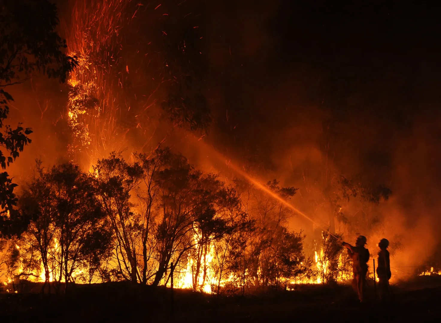
🔥 Part III: Wildfire & Smoke – What if the Road is Blocked?
In 2026, the question isn't if you’ll encounter smoke on a cross-country trip, but how close the flames will get. Wildfires move faster than most people realize, often jumping highways in minutes. If your GPS suddenly flashes red or you smell "campfire" while driving at 70 mph, here is your survival protocol.
1. The "Red Zone" Decision: To Pivot or Push?
The moment you see a "Road Closed" sign due to fire, do not attempt to find a "backdoor" gravel road. * The Danger: Unpaved forest roads are often one-way and can become death traps if the wind shifts.
-
The Rule: If the main artery is closed, the area is unsafe. Immediately use Google Maps to find the nearest major city away from the wind direction.
-
Check the Perimeter: Open Watch Duty. If the fire is "0% contained" and moving toward your path, abandon your itinerary for at least 200 miles.
2. If You Are Trapped on the Road
If smoke becomes thick and you cannot turn around:
-
The "Enclosure" Maneuver: Roll up all windows and switch your AC to Recirculation Mode. This prevents the system from pulling in outside smoke and embers.
-
Lights On: Turn on your headlights and hazard lights. Smoke can reduce visibility to near-zero, similar to a heavy fog.
-
Stay in the Vehicle: Your car is a shield against radiant heat. Do not leave the vehicle unless it is physically on fire.
-
Find a "Safe Anchor": If you must stop, look for a "non-combustible" area—a large paved parking lot, a clear dirt patch, or a rocky outcrop away from tall grass and trees.
3. Navigating the "Smoke Apocalypse"
Even if the fire is 50 miles away, 2026's wind patterns can carry toxic PM2.5 particles across state lines.
-
Monitor the AQI: Use the Google Maps Air Quality layer. If the AQI exceeds 150 (Unhealthy), avoid any outdoor activity or hiking.
-
N95 is Mandatory: Standard cloth or surgical masks do nothing against wildfire smoke. Your 2026 glovebox must contain N95 or P100 respirators for every passenger.
-
The "Blue Sky" Pivot: Use Windy.com to check the "Smoke/Aerosol" forecast. Sometimes driving two hours East or West can take you from "Hazardous" grey skies to perfectly clear blue.
4. Evacuation Basics: The "Go-Bag" Shift
In 2026, if you are staying in a hotel or campsite in a High-Risk zone (like the Sierra Nevadas or the Cascades), keep your car backed into the parking space with a full tank of gas.
-
The "One-Minute" Rule: Have your essentials (ID, water, meds, electronics) in a single bag. If the sirens wail at 3:00 AM, you shouldn't be packing; you should be starting the engine.
⚠️ Wildfire Survival Checklist
| Item | Action |
| AC Setting | Recirculate Only. Prevents ash from entering lungs/engine. |
| Masks | N95/P100. Must be fitted tightly to the face. |
| Fuel | Never below 1/2 tank. Evacuation traffic jams burn fuel fast. |
| Visibility | Hazards ON. Treat smoke like a physical barrier. |
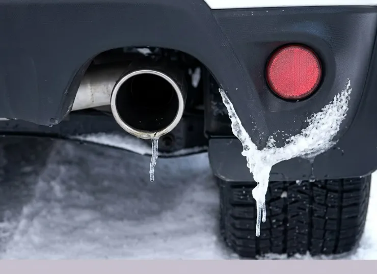
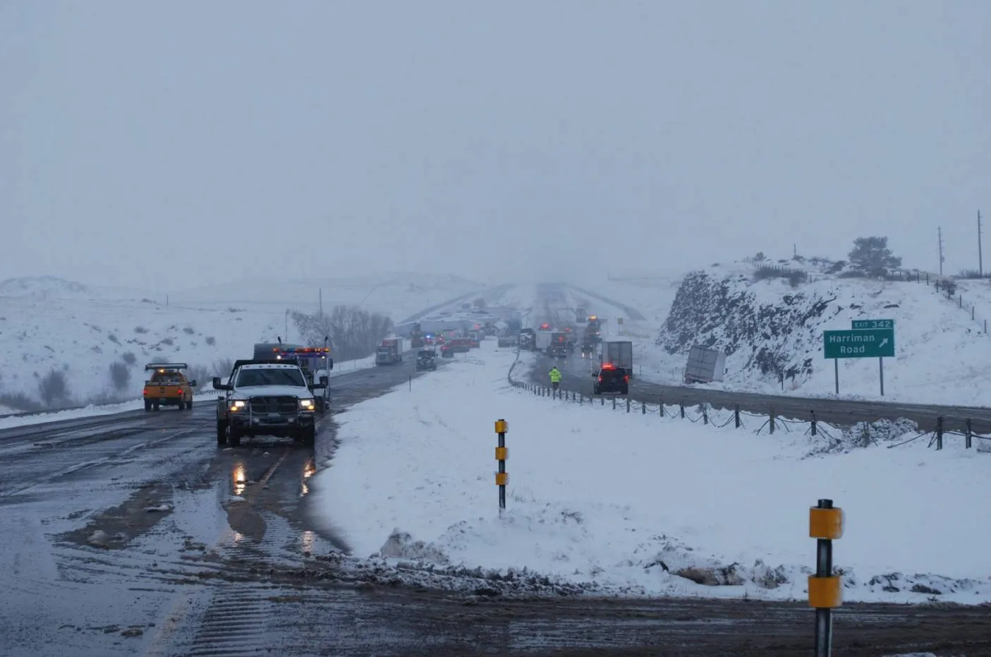
❄️ Part IV: Blizzards & Snow – Trapped in the Mountains?
In 2026, mountain passes like Colorado’s I-70 and California’s Donner Pass are seeing more "Flash Blizzards"—intense, high-moisture storms that dump inches of snow per hour. If the blue sky suddenly turns white and the road disappears, your priority shifts from "making time" to "staying alive."
1. The Golden Rule: Stay With the Vehicle
If you become stranded or visibility hits zero, do not leave your car.
-
The Danger: In a blizzard, you can lose your sense of direction within 10 feet of your vehicle. Exposure leads to hypothermia in minutes.
-
The Shelter: Your car is your primary survival pod. It is visible to snowplows and rescuers, and it provides a windbreak that no coat can match.
2. The 10-Minute Engine Rule
You need to stay warm, but you must conserve fuel and avoid a silent killer.
-
The Routine: Run the engine and heater for 10 minutes every hour to take the chill off.
-
The Exhaust Check: CRITICAL: Before starting the engine, ensure the exhaust pipe is clear of snow. If it’s blocked, carbon monoxide will back up into the cabin.
-
Ventilation: Crack a downwind window slightly while the engine is running to ensure fresh air circulation.
3. Visibility for Rescuers
Rescuers in 2026 use a mix of thermal imaging and visual sweeps. Make yourself easy to find:
-
The "Antenna Signal": Tie a brightly colored cloth (preferably red or orange) to your antenna or door handle.
-
Internal Lights: At night, turn on your dome light while the engine is running. It uses minimal power but makes the car glow like a lantern in the snow.
-
The Hood Signal: Once the snow stops falling, raise your hood to signal to passing plows or aircraft that you are in distress.
4. 2026 High-Tech Winter Survival Gear
A standard scraper isn't enough for 2026 mountain travel. Your trunk needs:
-
Portable Power Station: Units like an EcoFlow or Jackery can run an electric blanket for hours without draining your car battery.
-
LED Road Flares: Traditional flares burn out; battery-powered LED beacons can pulse for 24+ hours in a whiteout.
-
Traction Boards: Forget cat litter; in 2026, lightweight nylon traction boards (like MAXTRAX) are the only way to get a heavy vehicle out of a deep snowbank solo.
-
Satellite Communicator: In 2026, many mountain passes remain cellular "dead zones." A device like a Garmin inReach or the iPhone Satellite SOS is your only way to call for help when the towers are down.
🚨 Snow Survival "Do's and Don'ts"
| Do | Don't |
| Do keep your gas tank at least half full at all times. | Don't use cruise control on icy or snowy mountain roads. |
| Do exercise your arms and legs to keep blood flowing. | Don't fall asleep if you are alone; stay alert for rescuers. |
| Do eat and drink (melted) snow to stay hydrated. | Don't eat raw snow—it drops your core temperature. |
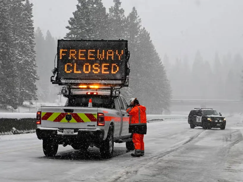
🗺️ Part V: Emergency Route Planning – Don't Follow the "Shortcut"
In 2026, the phrase "The GPS says this way is faster" has become a dangerous trap. As major arteries like I-80 or I-10 face emergency closures due to wildfires or blizzards, navigation AI often reroutes thousands of vehicles onto narrow, unpaved backroads. These "shortcuts" are rarely inspected for safety and can lead to disaster.
1. The "Dead End" Algorithm Trap
Modern navigation apps prioritize time above all else. During a mass evacuation or highway closure, the AI may suggest a forest service road or a mountain trail to save 20 minutes.
-
The Reality Check: These roads are often not maintained, lack cell service, and are too narrow for two-way traffic. If a fire shifts or a snowplow hasn't passed, you will be trapped with no way to turn around.
-
The 2026 Rule: Stick to State Highways and Interstates unless a uniformed official (Police/National Guard) directs you otherwise. A 2-hour delay on a paved highway is safer than a "10-minute" shortcut into a canyon.
2. Verify with "Human-in-the-Loop" Data
Don't trust a single source. Cross-reference your route using the Trinity of Verification:
-
Google Maps/Waze: Check for the "Red Line" (Live Traffic). If the "shortcut" shows no traffic data, it likely means there are no cell towers there—and no one to help if you break down.
-
State 511 Apps: Look for the "Truck Route" designation. If a road isn't cleared for semi-trucks, your SUV or camper shouldn't be there during an emergency.
-
Local DOT Social Media: In 2026, State DOTs (Department of Transportation) post live video updates from plow cams and fire-watchers. Check their feeds before committing to a detour.
3. The "Point of No Return" Calculation
Before taking any detour in the 2026 landscape, perform a quick "Reality Check" on your resources:
-
Fuel/Charge: Does this detour add 50 miles? If you have less than a 1/3 tank, do not take the detour. Stay on the main road and find a station.
-
Daylight: Never attempt an unfamiliar emergency detour in the mountains or desert at night. Visibility is your best defense against washouts and debris.
-
The "U-Turn" Test: If the road narrows to the point where you cannot perform a 3-point turn, stop and reverse immediately.
4. Communication in the "Dark Zones"
If you must take a secondary road, assume you will lose signal.
-
The Breadcrumb Method: Before leaving the main highway, text your intended detour route and your "Estimated Time of Emergence" to a contact who isn't in the car.
-
Satellite SOS: If you are using a Garmin inReach or iPhone Satellite Link, keep the device on the dashboard. In 2026, these devices can now send basic "I am on Detour X" pings to emergency contacts without a cell signal.
🛑 Detour Decision Matrix
| Scenario | Action |
| GPS suggests a dirt/gravel road. | REJECT. Stay on pavement. |
| Paved detour has no cell service. | CAUTION. Proceed only if you have a physical/offline map. |
| Detour is a "Seasonal" pass. | REJECT in Winter. These are rarely plowed. |
| Official sign says "Local Traffic Only." | REJECT. You will likely hit a dead end or a washout. |
🆘 Part VI. If You Get Stuck: Survival Mode
In 2026, the "Ultimate Road Trip" can turn into a survival situation in heartbeats. Whether it’s a total mechanical failure in a 115°F desert, a landslide on a remote mountain pass, or being boxed in by a shifting wildfire, your survival depends on The Rule of Three and your ability to stay calm.
1. The "S.T.O.P." Protocol
The moment you realize you are stuck and help is not immediate, perform the S.T.O.P. maneuver:
-
S – Sit Down: Do not pace or panic. Panic leads to sweat (dehydration) and poor decisions.
-
T – Think: Assess your resources. How much water is left? Is the car's battery healthy?
-
O – Observe: Look at the weather and terrain. Are you in a low-lying area prone to flash floods? Is the wind blowing smoke toward you?
-
P – Plan: Decide on a course of action and stick to it unless the environment forces a change.
2. Water: Your Most Precious Asset
In 2026's extreme heat cycles, you can survive weeks without food but only hours without water.
-
The Rationing Myth: Do not "ration" water to the point of dehydration. Drink when you are thirsty, but avoid exertion that causes sweating.
-
The Car as a Resource: If you run out of bottled water, your car's AC system produces condensation. In an absolute emergency, this liquid can be collected, though it must be filtered.
3. Signaling for Help (Analog vs. Digital)
If your 2026 tech fails, go old school:
-
The Ground Signal: Create a large "X" or "SOS" on the ground using rocks, logs, or even floor mats. It needs to be at least 10 feet long to be seen from search aircraft.
-
Mirror Signaling: Use your car’s side-view mirror or a smartphone screen to reflect sunlight toward distant planes or vehicles.
-
The 3-Blast Rule: Three loud blasts on your car horn or three whistles is the universal signal for distress.
4. Psychological Survival: The "250-Year" Perspective
2026 marks 250 years of American resilience. Remind yourself that help is coming.
-
Inventory your "wins": You have a vehicle for shelter, you have a survival kit, and you left a trip plan with friends.
-
Avoid the "Walk Out" Temptation: 90% of road trip fatalities occur when a person leaves their vehicle to find help. Stay with the car. It is a much larger target for rescuers to find than a single person walking through the brush.
5. Final Checklist: The Last Stand
-
Conserve Battery: Turn off all non-essential electronics. Use your satellite messenger only for scheduled check-ins.
-
Temperature Regulation: In the heat, stay in the shade of the car (not inside it if the engine is off). In the cold, huddle with passengers and use floor mats as extra insulation.
-
Visible ID: Keep your ID and a written "Last Known Situation" note on the dashboard where it can be seen through the windshield.
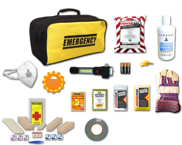
🎒 Part VII: Your 2026 Ultimate Emergency Kit
Since we’ve covered the "Survival Mode" mindset, let’s get tactical with the physical gear. In 2026, a standard "jumper cables and a flashlight" kit is insufficient. Given the El Niño volatility and USA 250 crowds, your trunk needs to be a self-contained life-support system.
Think of your vehicle as a lifeboat. If a wildfire closes the highway or a blizzard traps you in a pass, these items are your primary line of defense.
1. The "Air & Fire" Module
In 2026, the biggest threat to road trippers isn't the crash; it's the smoke.
-
N95/P100 Respirators: Pack at least three per person. Wildfire ash is toxic; a standard surgical mask won't filter PM2.5 particles.
-
Portable Air Purifier: Small, USB-C powered HEPA filters (like those from IQAir or Wynd) can keep the cabin air breathable if you're stuck in a smoke plume.
-
Fire Extinguisher (Class ABC): Ensure it is rated for brush and chemical fires.
2. The "Climate Tech" Module
-
Portable Power Station: A 500Wh+ unit (EcoFlow/Jackery) is essential. It can power an electric blanket in winter or a 12V fridge/fan in summer without draining your car’s starter battery.
-
Satellite Messenger: Do not rely on 5G. A Garmin inReach or Zoleo allows you to send an SOS via satellite when you are in a "Dead Zone."
-
LED Road Beacons: Ditch the old chemical flares. Rechargeable LED pucks last for 24+ hours and are much safer to use in dry, fire-prone grass.
3. The "Life Support" Module (Food & Water)
-
Water Purification: Carry 3 gallons of potable water per person, but also pack a LifeStraw or Sawyer Squeeze filter in case you need to source water from a stream or cattle tank.
-
Calorie-Dense Food: Pack "No-Cook" options. MREs (Meals Ready to Eat) or high-protein bars. In 2026, avoid anything that requires a stove, as Stage II Fire Bans often prohibit open flames.
-
Emergency Bivvy/Blanket: Not the cheap foil ones; get a thermal bivvy (like S.O.L.) that reflects 90% of body heat and won't rip in the wind.
4. The "Mechanical Resilience" Module
-
Traction Boards: Essential for sand (Southwest) or deep snow (Rockies).
-
Jump Starter Power Bank: A lithium-ion jump starter (like NOCO) that can start your car independently without needing another vehicle.
-
Full-Sized Spare: In 2026, many new cars come with "fix-a-flat" kits. For a cross-country trip, buy a real spare tire. A can of goo won't fix a sidewall tear on a remote Nevada road.
🛡️ The 2026 "Go-Bag" Summary Table
| Category | Item | Why It’s Vital in 2026 |
| Breathing | N95 Masks | Protecting lungs from record wildfire smoke. |
| Comms | Satellite SOS | Reliable help in the 20% of the US with no cell. |
| Traction | Traction Boards | Escaping mud, sand, or snow without a tow truck. |
| Warmth | Electric Blanket | Zero-emissions heat during a "Engine-Off" blizzard. |
Final Pro-Tip: Inspect your kit every 3 months. Lithium batteries hate extreme heat, and water jugs can degrade. 2026 is the year of the "Prepared Explorer"—make sure your gear is as ready as you are.
⚠️ Part VIII: High-Risk Iconic Routes (The 2026 Red List)
If your 2026 itinerary includes these legends, you need more than just a camera. These "Bucket List" drives now require specific tactical planning to navigate safely.
1. The Million Dollar Highway (US-550), Colorado
-
The Vibe: 25 miles of sheer cliffs with no guardrails between Silverton and Ouray.
-
The 2026 Risk: Increasing "Flash Blizzards" and late-season May snowstorms. As of May 2026, CDOT has enforced strict Traction Laws through late spring.
-
Survival Pivot: If the forecast calls for even a "dusting" of snow, do not attempt this route. One misjudged turn on icy pavement is unforgiving.
2. Pacific Coast Highway (Hwy 1), California
-
The Vibe: The ultimate coastal cruise.
-
The 2026 Risk: While the "Regent’s Slide" section reopened in early 2026, the route is now highly sensitive to Atmospheric Rivers. Heavy rains cause immediate mudslides, and summer heat brings Red Flag Warnings (high fire risk).
-
Survival Pivot: Always have a "Big Sur Escape Plan." If rain is heavy, Hwy 1 can close with 30 minutes' notice, leaving you trapped between landslides.
3. Going-to-the-Sun Road, Montana (Glacier NP)
-
The Vibe: Alpine perfection.
-
The 2026 Risk: Glacier National Park is a primary Wildfire Hotspot. In 2026, a new "Ticketed Shuttle System" is in place to manage record crowds. Smoke from neighboring Idaho often settles in the valley, dropping visibility to near-zero.
-
Survival Pivot: You must check the Watch Duty perimeter for the "Flathead Valley" daily. If a fire starts west of the park, the Sun Road becomes a funnel for smoke.
4. I-70 Mountain Corridor, Colorado
-
The Vibe: The gateway to the Rockies.
-
The 2026 Risk: This is officially one of the deadliest road stretches in the US due to the combination of extreme altitude (11,000+ ft), heavy semi-truck traffic, and sudden "whiteout" squalls at the Eisenhower Tunnel.
-
Survival Pivot: Avoid weekend travel at all costs. Friday evenings and Sunday afternoons in 2026 are prone to "Gridlock Snow Traps" where cars are stranded for 6+ hours in freezing temps.
5. US-50: "The Loneliest Road," Nevada
-
The Vibe: Pure, desolate Americana.
-
The 2026 Risk: Record-breaking heatwaves. In July 2026, daytime temps on the basin floors can exceed 115°F.
-
Survival Pivot: This is a Cellular Dead Zone. If your car overheats here, you are in a life-threatening situation. Carry 5 gallons of water and a Satellite SOS device. Do not rely on passing motorists; they are as "lonely" as the road implies.
🚦 2026 Route Risk Summary
| Route | Primary Threat | Best Time to Drive |
| US-550 (CO) | Snow/Ice (No Guardrails) | July – September |
| Hwy 1 (CA) | Mudslides / Wildfire | April – June |
| I-70 (CO) | Blizzards / Traffic | Mid-week, Mid-day |
| Sun Road (MT) | Wildfire Smoke | Early July (Pre-Fire Season) |
| US-50 (NV) | Extreme Heat / Isolation | October – November |
❓ Part IX: Frequently Asked Questions (FAQ)
Q1: What is the single most important app to have in 2026?
A: Watch Duty. While Google Maps is essential for navigation, Watch Duty provides human-vetted, real-time wildfire intelligence that can save your life. In a year defined by "Smoke Season," knowing the fire perimeter before you see the flames is critical.
Q2: Can I rely on my EV for a cross-country trip in 2026?
A: Yes, but with caveats. The 2026 charging network is the most robust in history thanks to the NEVI program, but "Charging Deserts" still exist in rural Wyoming, Montana, and West Texas. Use PlugShare to verify charger reliability, and always keep 50 miles of "buffer" range in case of a road closure detour.
Q3: Can I rely on my EV for a cross-country trip in 2026?
A: Yes, but with caveats. The 2026 charging network is the most robust in history thanks to the NEVI program, but "Charging Deserts" still exist in rural Wyoming, Montana, and West Texas. Use PlugShare to verify charger reliability, and always keep 50 miles of "buffer" range in case of a road closure detour.
Q4: Is it safe to drive through smoke if the road is open?
A: Only if visibility is clear. If you can see the road and there are no evacuation orders, you can proceed, but you must switch your AC to Recirculation Mode and wear an N95 mask inside the car. If smoke reduces visibility to less than a few car lengths, pull over to a paved area and wait for it to clear.
Q5: How do I handle the "No Reservation" policy at National Parks?
A: 2026 is the year of the "Early Bird." With the rollback of reservation systems at parks like Yosemite and Arches, gates often reach capacity by 6:30 AM. Plan to arrive before sunrise or visit after 4:00 PM for "Golden Hour" when the morning crowds begin to exit.
Q6: What should I do if my GPS tells me to take a dirt road detour?
A: Ignore it. In an emergency (wildfire or blizzard), algorithms often suggest unpaved backroads that are not maintained or are too narrow for emergency vehicles. Stick to paved State Highways and Interstates unless a uniformed officer tells you otherwise.
Q7: Do I really need a Satellite Messenger if I have an iPhone?
A: Recommended. While newer iPhones have Satellite SOS, a dedicated device like a Garmin inReach allows for two-way messaging with family and provides more reliable GPS tracking in deep canyons or heavy timber where phone antennas might struggle.
Q8: Will my insurance cover me if I drive past a "Road Closed" sign?
A: Almost certainly NO. Breaking the law by entering a closed zone usually voids your collision and liability coverage. You’ll be paying for that rental car out of pocket!
Q9: What if I’m stuck and have no signal?
A: In 2026, most new iPhones and high-end Androids have Satellite SOS. If it’s a life-threatening emergency, use it! Otherwise, stay with your vehicle. It's much easier for rescuers to find a car than a person wandering in the woods.
Q10: How much extra time should I budget?
A: For a 2026 road trip, add 20% "buffer time." If a drive says 5 hours, assume it might take 7. This prevents you from rushing through dangerous conditions just to make a hotel check-in.
Q11: What is the best time of year for a cross-country road trip in 2026?
A: Traditionally, summer was the peak season. However, due to extreme heat and peak wildfire risks in July and August, the new "Golden Windows" for a cross-country trip are mid-May to early June or late September to October. These shoulder seasons offer milder weather, fewer orange construction barrels, and slightly less crowd congestion.
🏁 Final Thought: The New Frontier of the Open Road
The American road trip has always been about more than just the destination; it is a rite of passage, a slow-motion immersion into the vast, shifting heart of a continent. In 2026, as we celebrate 250 years of this grand experiment, the road is asking something new of us. It is asking for our attention.
The era of the "autopilot" vacation—where we plug in a zip code and tune out the world—is over. Today’s landscape is a living, breathing entity. It speaks in the language of shifting winds, rising rivers, and the amber glow of a distant ridge. To travel well in 2026 is to listen to those signals.
Yes, the survival kits are heavier and the apps are more complex, but the reward remains unchanged. There is still nothing that compares to the silence of a Mojave dawn, the mist clinging to a redwood canopy, or the shared nod with a fellow traveler at a remote charging station.
By preparing for the worst, you buy yourself the freedom to enjoy the best. You aren't just a driver anymore; you are a steward of your own adventure. So, pack the masks, download the maps, and keep an eye on the horizon. The road is still open, it’s still beautiful, and it’s waiting for those brave enough to meet it on its own terms. 💎✨
Safe travels. See you out there. 🏎️💨
Relalted Guide: Ultimate Guide to Parking in the U.S.; U.S. Rental Car Insurance Guide: LDW, CDW, SLI ; Route 66 Road Trip Guide